At a Glacial Pace

DSC_0207

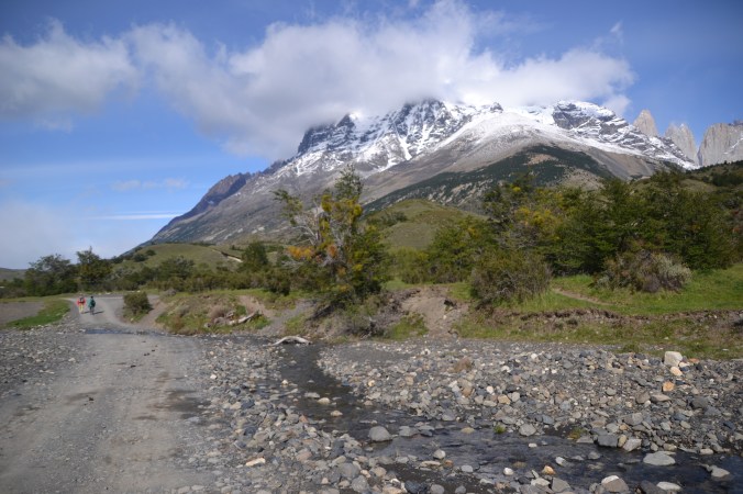
Three miles wide at the snout, nineteen miles long, filling the expanse between the mountains like builders’ foam; the powder blue ice, its hollows and crevices appearing backlit by the water within, juxtaposed with the deep green coniferous trees and the stark grey-black of the mountains, lightly dusted with snow and engulfed in low cloud at the margins; a wall of ice, striped with seams of deeper blue and black, rising an average of 240 foot above the surface of Largo Argentino, carved by nature into tens of thousands of tightly-packed columns ranking into the distance like an ancient army massed for battle.

The Perito Moreno glacier in the far South-West of Argentina feeds from the Southern Patagonian Ice Field which straddles the border with Chile and is the last redoubt of an Ice Age which ended 11,000 years ago. It sprawls over an area more than four times bigger than Manhattan or about two and a half times the size of Barcelona.

DSC_0209

Boardwalks on multiple levels connected by stairs take visitors within a few hundred feet of the snout. Pops and cracks echo from around the glacier as if hunters were out on its surface shooting birds. Calved ice litters the waters around it.

Hours could easily be spent just gazing in awe at the glacier and listening to its cracks and creaks and bangs.  But I was not just there to look.

DSC_0172

Three years earlier in New Zealand, I arrived in Franz Josef too late to be able to hike on the glacier, as I had hoped, and had to make do with seeing it from the foot of the mountain on my way to the bus the next morning. Now, on a different continent but back in the Southern Hemisphere, the chance had come round again.

I took a boat across the lake to the shelter on the shore by the South Wall, where I was herded into a group of about 15 and had crampons attached to my boots. Two groups were out on the ice already, one about a third of the way up, the other about a third from the summit.

15027709_1834854110091647_2786598726016745399_n

In the middle of the briefing, there was a boom as if of a cannon and then a rumbling, shuttering sound like an office block succumbing to the wrecking ball. I turned and watched as a section of ice thirty, forty, fifty feet high detached from the glacier and slid vertically into the lake, rose again as pulverised fragments and caused a tumult in the water.

We started our ascent.  The crampons, impossible on land, were intuitive on the ice. We moved slowly, in file, behind the guide.  The route weaved between cracks and ponds and glacier mills, where surface meltwater spirals into a shaft in the ice. The ice glistened in the sun. We drank the coolest, freshest water straight from the glacier.

imageonline-co-straightend-image.png

Then, at the summit, the first of the guides produced whisky and glasses; the other harvested ice from the glacier with an axe. ¡Salud! We drank the whisky tempered with chunks of Perito Moreno, packed up and made our way back to the shelter.

© Richard Senior 2019


What a Paine: Trekking in Patagonia

DSC_0585

The shuttle bus came at first light. The passengers who boarded at the stops up the hill were layered up in outdoor gear. Some carried tents and stoves. They mumbled buen’ dia’s and hellos on their way to their seats. At the terminal on the outskirts, where I had arrived from Argentina two days before, the bigger buses were taking on passengers for the Torres del Paine National Park.

It was a two-and-a-half hour journey, familiar from the minibus tour I had taken on the first day to try to get a feel for the park: mountains, lakes, rivers, waterfalls, icebergs, sun, wind and rain in succession, condors and guanacos, the lesser known of the South American camelids.

DSC_0640

My plan was to hike the first leg of the W Circuit, the iconic five-day trek through the park. The owner of my hostel, who also did a brisk trade in hiring out camping gear, assured me it would be a long day’s trek. It did not really look it on the map. The round trip to Mirador Torres del Paine and back was a little under 15 miles, and I often walked that sort of distance then and it might take me a morning but not a full day. There was a shorter hike I could tag on at the end if I had time to spare.

The peaks soared up in the distance, dusted with snow, obscured by cloud. A desultory stream trickled over rocks at the side of the track. There were scrubby grasslands and hardy trees. To the right was the refugio where the W-trekkers spend their first night. A gaucho galloped a bay horse towards it.

rsz_dsc_0687

It was warm, now, in the morning sun and I peeled off two layers and stuffed them into my rucksack. About half an hour in, the path turned towards the mountains, became sinuous and steepened. I snarled up behind a tour group then managed to pass. There were conifers bent at an angle from the wind and pretty red alpine flowers.

In the first hour, according to my stats, I climbed from 400ft above sea to over 1000. By two hours, I was at 1500, by three at 2,300. There was a clatter of hooves behind me. I pressed myself to the side of the track as more gauchos passed with supplies for the refugios along the trail. I looked back at a lake far below and the snowy mountains beyond it.

DSC_0691

The trail cut diagonally along one side of a valley. The opposing peaks appeared coal black, except where they were streaked with snow. The snow lay thickly on more distant mountains and the winds swirled it round their peaks. The river bubbled over rocks at the foot of the valley.  The Patagonian wind howled all at once. The temperature plummeted. I wrestled first a softshell then a puffa jacket from my rucksack and they flapped like a sail ripped from the mast in a storm.

Up and over the ridge and the wind disappeared as suddenly as it had arrived and I pulled down zips, pushed up sleeves and tore off layers again. The trail led into the forest and I walked under coniferous trees. I crossed and re-crossed and walked along the river. The water was turquoise and clear and frothed as it eddied round rocks. The boulders beside it were bleached by the sun. The bridges were wooden and rickety. One crossing was just a broken ladder and a few planks of wood slung into the shallows.  I tramped through the grounds of a refugio with tents wherever there was space and travellers lounging on the benches outside the dorms.

15078751_1837481676495557_5178498991990586088_n

It was somewhere around lunchtime when I reached the Torres camp site and I stopped to eat the empanadas de pino from the supermarket in Puerto Natales. What I took to be a wolf emerged from the trees and trotted passed me and I jumped up in alarm and knocked over the bottle I had placed on the floor. The water dribbled over the dust as the animal loped through the campsite. No one else seemed to mind it and I think it was actually a grey fox, not a wolf. I picked up the bottle and salvaged what I could of the water and my pride.

The trail became markedly steeper from there and progress was slow as hikers in front picked their way over rocks, between boulders, relying increasingly on walking poles. There were repeated bottlenecks. Until then, my average pace had fluctuated between about 20 and 30 minutes a mile but now fell to almost 60. The frustration, though, fell away, at a little under 3000 ft above sea as I stood at the edge of the turquoise lake staring up at the three great shards of granite for which the park is named. Las Torres del Paine, ‘the Blue Towers’ in a mixture of Spanish and Tehuelche, the extinct native language of that part of Chilean Patagonia.

DSC_0666

It had taken four hours in all to reach the top and it would take another three and a half to get back to the refugio where I had seen the gaucho that morning. I had been naïve to imagine that I might have time to fit in more hiking that day. All that remained was to recline in the sun with a book and wait for the shuttle to Laguna Amarga, then pick up the bus back to Puerto Natales.

© Richard Senior 2019

24 Hours in Sokcho

DSC_0368

The bus from Gangneung pulled into Sokcho at 10.30. I spotted the guest house as we rounded the last corner and walked up there, dropped off my bags, picked up a map, and took a local bus out to Seoraksan National Park.

It was too late to think about doing the ten-hour round trip to the top of Daecheongong Peak and back; so I headed, instead, for Ulsanbawi which tops out at a more manageable 876m –  still 50 metres higher than the world’s tallest building. I was as well-prepared as ever with a vague tourist map, no water and ordinary street clothes.

DSC_0344

The path, only gently sloping to start with, meandered past a kneeling Buddha and stone lanterns and alongside a river which had dried to a trickle and was lined with blossoming cherry trees, and over an ornamental bridge, past a temple complex with kingfisher blue roof tiles and exquisitely painted eaves, and on and into the depths of the forest of deep green firs and brighter green deciduous trees from which – in the distance – the jagged peaks protruded.

I followed the path into the trees and over boulders and across more bridges and up and up, as the terrain became more difficult, and out onto a plateau where an ancient hermitage had been cut into the mountainside and up again to a spit of rock which I scrambled up and looked back across the expanse of the park into the floor of the valley way below. The peak, though, still brooded over me, hundreds of feet above. Its upper slopes looked more or less vertical.

DSC_0347

They were. There was an iron walkway up to the top with – depending on whom you ask – 800, 808, 888 or over 900 steps, which in any case is like walking halfway up the Empire State Building. I had aimed to get to the top without stopping but lost my resolve halfway up the walkway and stopped to rest, but only for a moment, because a sprightly old lady in luminous hiking gear surged past me and shamed me into pressing on.

The reward, though, for reaching the peak was a breathtaking view across the park, across the countryside, back to Sokcho and on to the coast and out over the Pacific.

DSC_0354

It was mid-afternoon by the time I got down, too late for lunch, too early for dinner, but I stopped anyway at an outdoor restaurant and ordered the local dish known as squid sundae, which sounds a bit Heston Blumenthal, but has nothing to do with the Western dessert of the same name. It is a squid body stuffed with diced pork, tofu, tentacles and shitake mushrooms, steamed and sliced into rings.

There was a shorter, easier trek through the woods, over rocks and bridges to the Yukdam Pokpo and Biryong Pokpo falls, and that passed an hour so before I got the bus back to Sokcho and poked around the fishing harbour and market and took the hand ferry across to the North Korean expat village (Sokcho was the wrong side of the border before the war and is an hour from the DMZ now).

11205992_1622313454679048_632365230945364815_n

Koreans are said to go Sokcho just for the mudeumhoe (raw fish platter) in which the fish is sliced carpaccio-style and served on bean thread noodles with the tableful of side dishes you always get in Korea. There was enough, this time, for a small group: a fried fish, sashimi, oysters, whelks, squid sundae, squash, soup, salad, kimchee (fermented cabbage) and goodness knows what else. Thankfully you are not expected to eat it all.

Then I was back on the intercity bus in the morning, heading for Chuncheon, the last stop en route to Seoul.

© Richard Senior 2015

The Inca Trail to Machu Picchu

DSC_0474

The train rattled alongside a furious river hemmed in by mountains as Andean flute music wafted from speakers above. Then it stopped, nowhere, just like a British train…except that this one was meant to.

Excuse me, esir, you need for to get off

What?”

You do the Inca Trail, no?”

Oh, yeah.

There was no station, no platform: we just opened the door, dropped to the track and crunched through the gravel until we got to a bridge more rickety even than any I saw in Laos. It swayed and creaked as I hurried across the rotten slats, expecting, any minute, that one would give way and leave me dangling over the river.

DSC_0489

It takes three or four days to walk the length of the Inca Trail, but we were cheating a little and starting two thirds of the way in. That still left a long day’s hike.

The trail led relentlessly upwards, snaked round the mountain, and continued upwards, until we had left the valley we started from way below and the river was but a scribble and the train track a toy shop display. We scrambled up Incan terraces, passed waterfalls which plunged gorgeously down the face of the rock, and looked across at the neighbour mountains carpeted with trees, and paused to contemplate flowers which erupted from the ledge in shocks of yellow and orange, and pink and red.

Once we saw porters from the four day trail, running down the mountain with mules-worth of weight on their backs. They carry the tents, the chairs, the stoves, the gas bottles and food so the tourists need not worry about weight.

DSC_0531

It started to rain and the clouds slipped down and filled the valley like expanding foam and, for an hour or two, we were walking above them.

Bepe, the guide, kept stopping so we had a chance to catch our breath and he had a chance to share his passion for orchids; but I wanted to press on and did, until I came to a sign with a picture of a bear and some text I did not understand and jumped to the wrong conclusion.

I had just read Bill Bryson’s A Walk in the Woods, in which he worries his way along the Appalachian Trail thinking about bear attacks. But there are no grizzlies in Peru, it turns out, just the spectacled bear: a shy little thing you would expect to have petite-bourgeois manners from the fifties and a bag full of marmalade sandwiches. The sign was urging the walkers not to bother the bears, not warning the walkers that the bears might bother them.

DSC_0532

I went ahead again, and passed a hard-looking man who glared from a step, and I remembered something I had read in a guidebook about muggings along the trail. Three more men emerged from shelter when I climbed up the steps of Inti Punku, the last but one of the ruins on the trail. “Buen’ dias,” one growled and I looked back with relief to see Bepe and the others at the foot of the steps.

Who were those dodgy bastards?” I asked after we turned the corner.

“The rangers,” Bepe said.

“Oh.”

“They’re making esure that nobody is still walking when the trail closes.”

“Ah.”

We would, he said, have had a good view of Machu Picchu by then, if it were not for the clouds. I thought he might have kept that to himself. But as we walked on, the clouds dissolved and the iconic image materialised before us, just as it is in the brochures. It was a magical effect.

DSC_0557

© Richard Senior 2015