The Sichuan Teahouse

He Ming Teahouse, People’s Park

An old man had fallen asleep in his chair. His head lolled back, his mouth hung open. Another peered at a newspaper. A group in their twenties were lost in their smartphones. There was a click of mahjong tiles, the slapping of cards onto tables. The ear-cleaner walked round with a fistful of diabolical tools. He clanged them together in terrorem. A masseur gave a treatment which involved the techniques that school bullies use to make other children cry.  

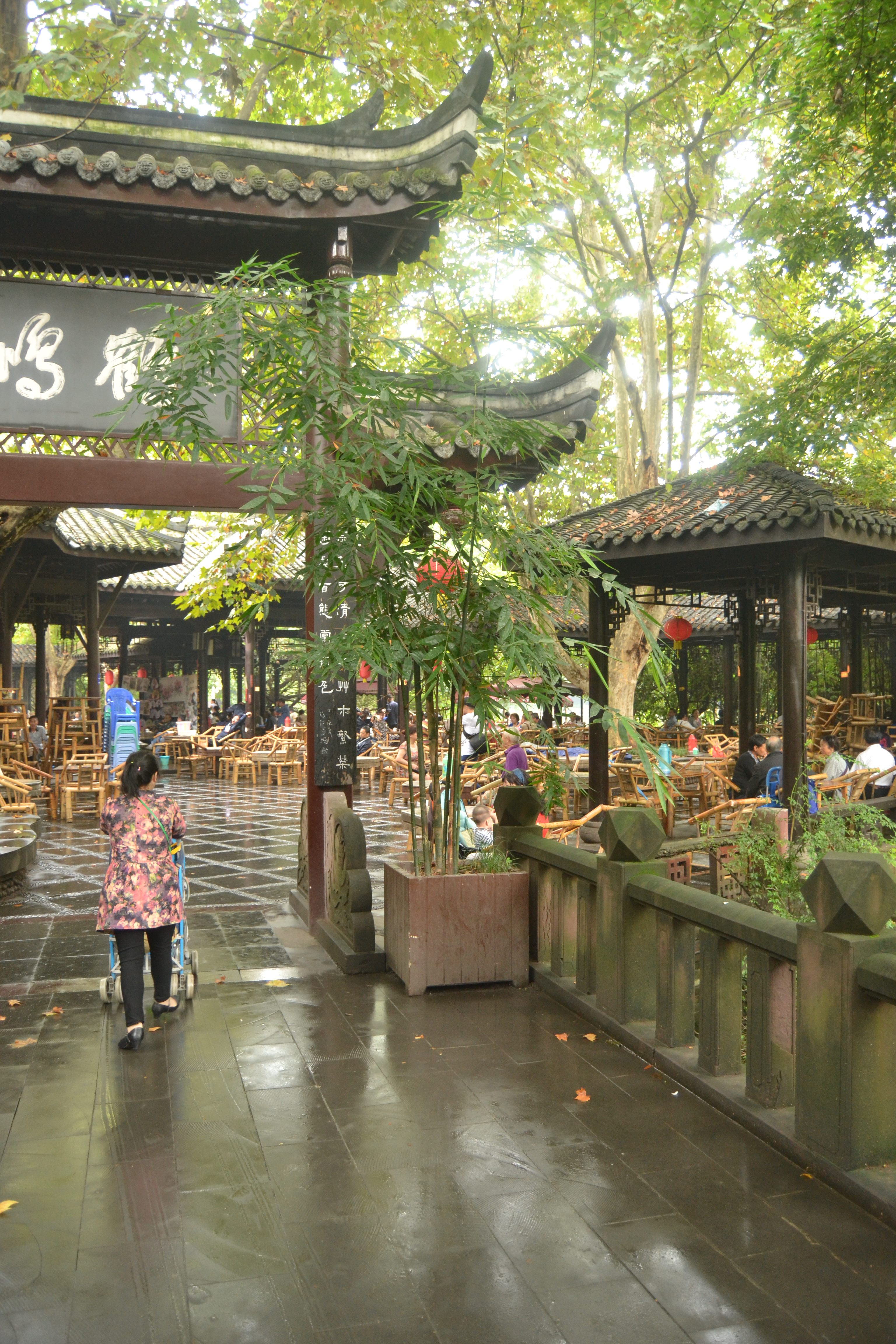
The chairs were fashioned from bamboo, the tops of the tables were battered. They were laid out under parasols, themselves under a canopy of trees. But shade is seldom needed in Chengdu. You are, as the saying goes, more likely to see a teahouse than a sunny day.

This image has an empty alt attribute; its file name is teahouse_in_peoples_park_-_chengdu_china_-_dsc05371.jpg
Daderot, CC0, via Wikimedia Commons

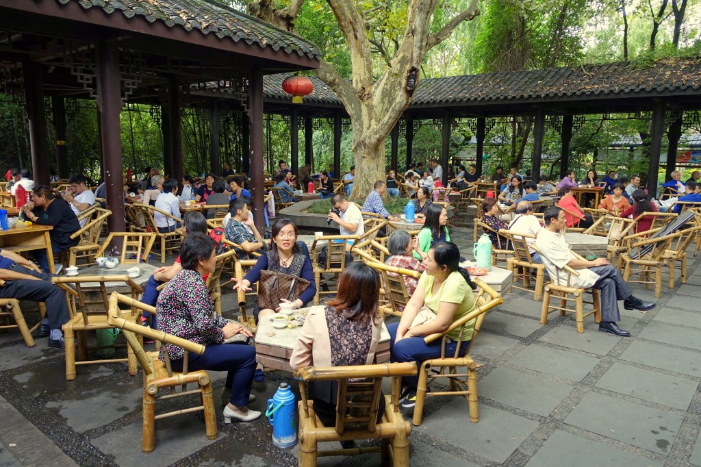
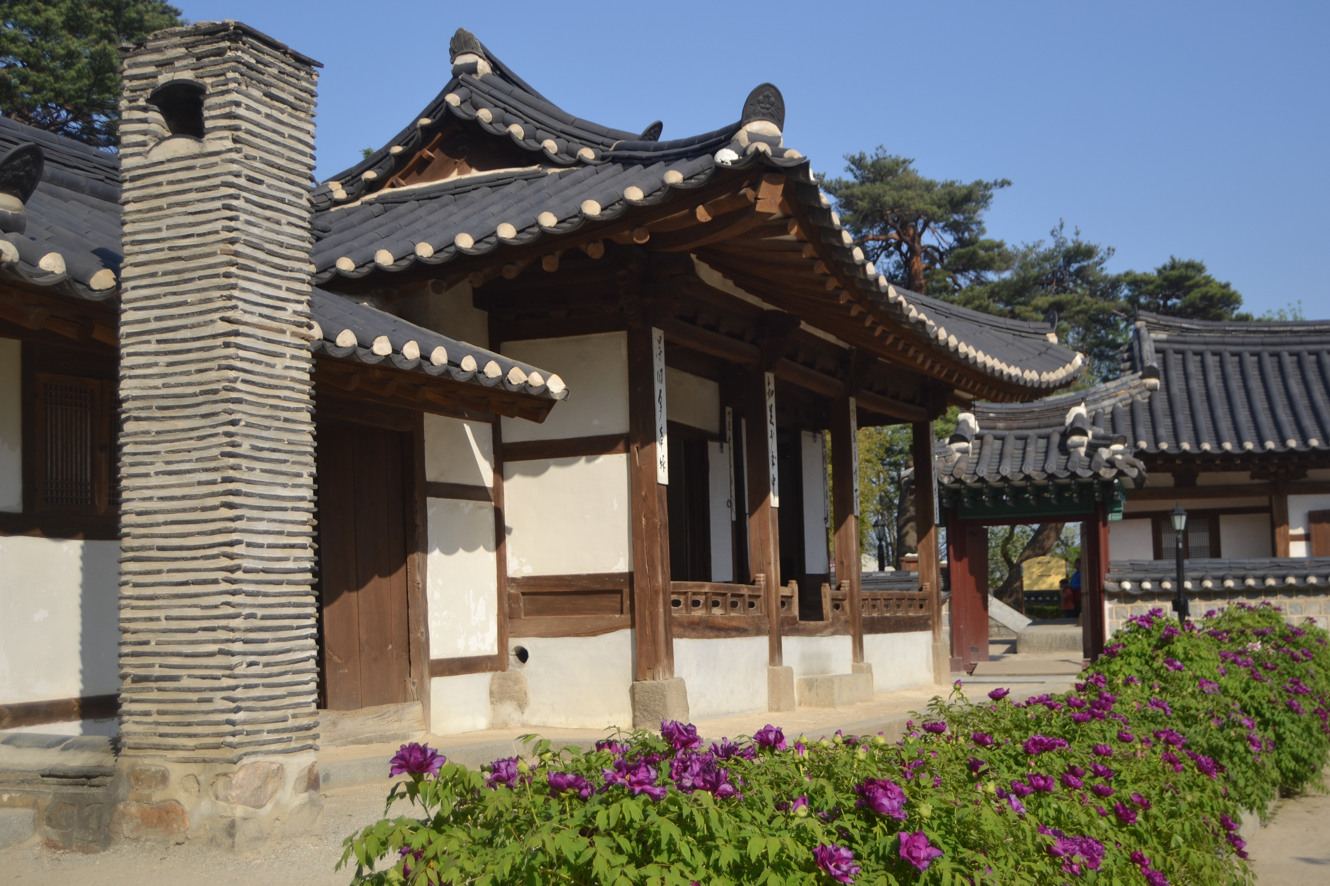
Teahouses are an ancient institution in Sichuan Province. They have been around since the Tang Dynasty (618-907 CE). By the end of the nineteenth century, there was almost one for every street in Chengdu. They were always a lot more than somewhere to go to drink tea. Traders would do business from them. Gangsters would sell opium at them. People would go there to catch up on news and gossip.

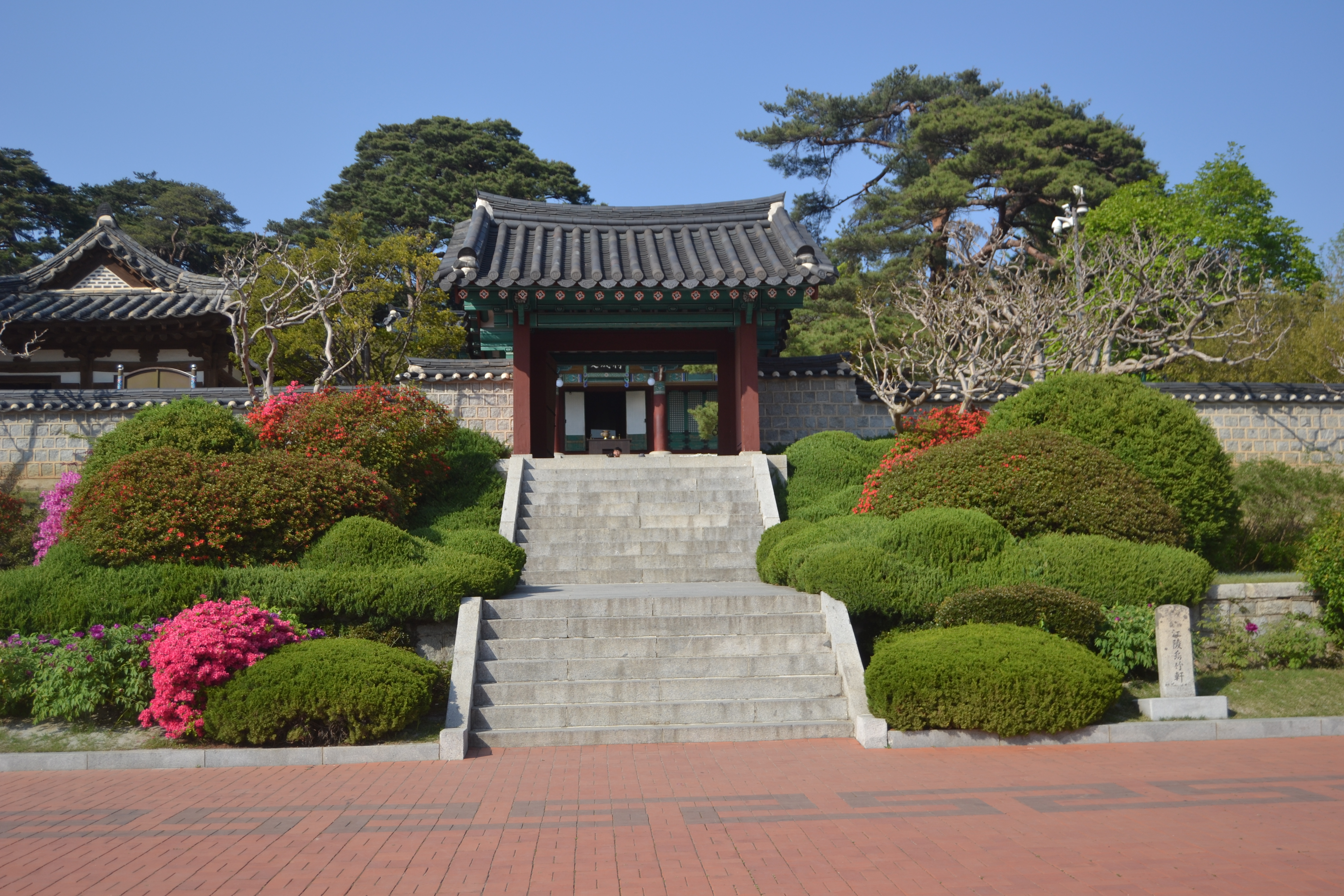
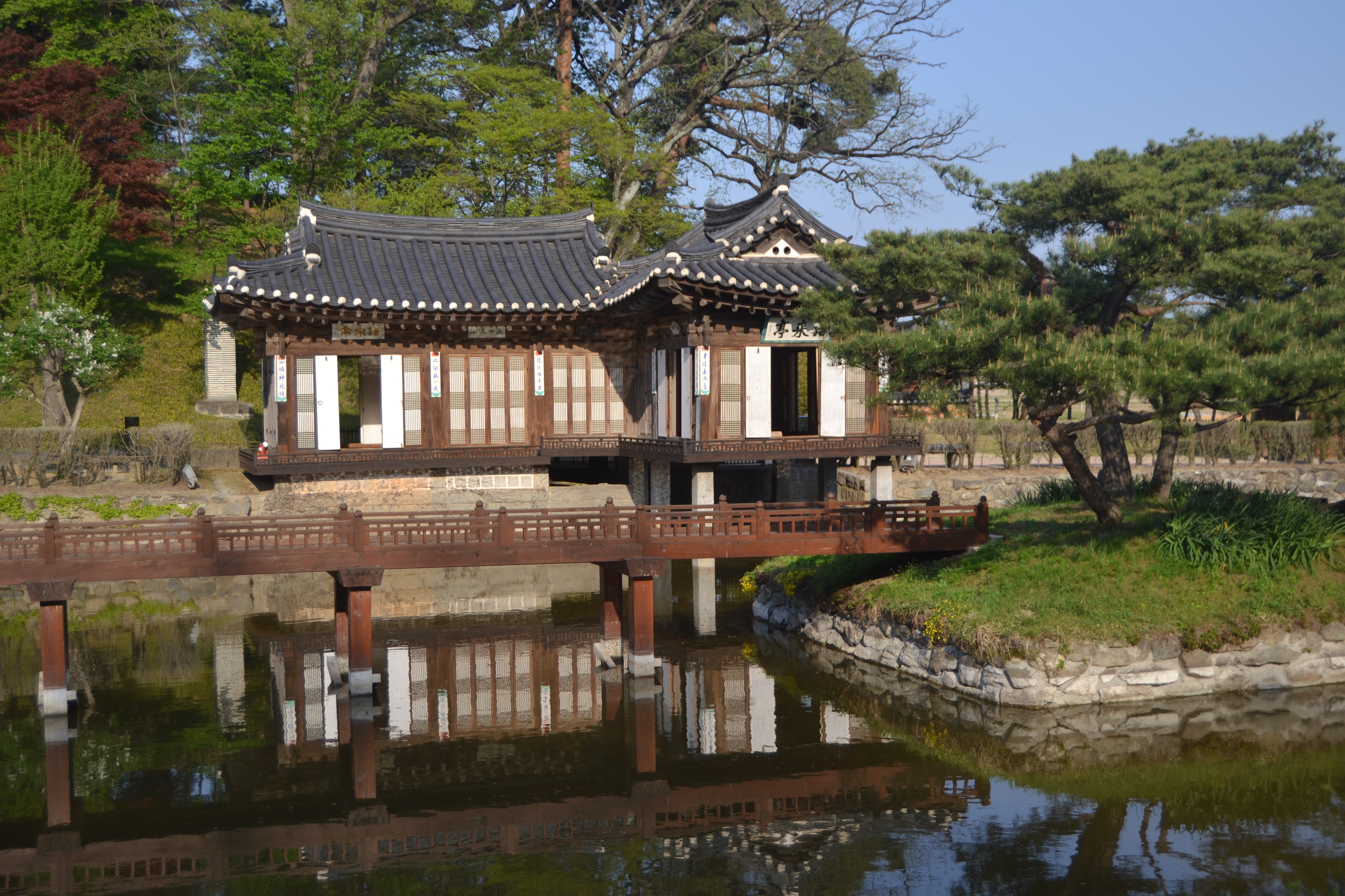
The He Ming Teahouse on the lake in the People’s Park is over a century old. The name means ‘singing crane’. It is connected by a footbridge to the smaller Yongju Teahouse on Goldfish Island in the middle of the lake where there is a pond which teems with fish.

Daderot, CC0, via Wikimedia Commons

A stream leads from the lake along the top of the park to the Zhen Liu Teahouse, where I settled and ordered jasmine tea. The name in Chinese is bi tan piao xue, which I am told means ‘snowflakes floating on a green lake’.

The tea leaves came in a sachet with a cup with a lid and no handle and a large flask of hot water. There is an etiquette to drinking the tea. Some grasp the saucer with one hand, lift the lid with the other and use it to scoop away floating leaves. Others hold the cup by the rim with their thumb and middle finger and use the index finger to push aside the lid just far enough to let the tea flow while filtering out the leaves. I learned all that later, though.

Photo by CEphoto, Uwe Aranas (Wikimedia Commons)

Elsewhere in the People’s Park there are orchids and bonsai trees. There are paifang gates, pagodas and humpbacked bridges. There are caricaturists and fortune-tellers and musicians. There are strollers and joggers and groups doing tai chi or dancing to music. There is ballroom and fan dancing and something you might do in a class at the gym.

Old men practice water calligraphy. They describe the characters on paving stones with giant paintbrushes dipped in water. Couples rent boats and pootle about on the lake. People fly kites and play badminton with tennis balls and keepie-uppie with oversized shuttlecocks. The game and the shuttlecock are called jianzi.

Spin a wheel to determine which picture the vendor will recreate in caramel dribbled from a ladle and mount on a skewer. It might be a butterfly, a cockerel, a songbird, a dragonfly or a slightly incongruous strawberry. Watch other vendors make san da pao by tugging pieces from a big ball of sticky rice, shaping them into smaller balls and bouncing them – for some reason – off cymbals into a tub of sweet bean flour.

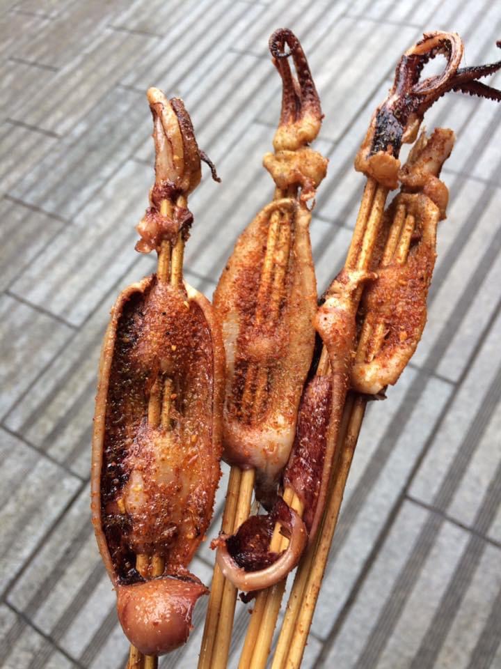
Both looked two sickly for me. I snacked instead on squid threaded onto skewers, sprinkled with chilli powder and grilled on a plancha.

I passed a few hours at the People’s Park. Locals will make a day of it if they can.

© Richard Senior 2021

Cycling the Golden Gate Bridge to Sausalito and Tiburon

I picked up the bike at the rental store on Pier 39, upwind of the sealions, and pedalled along the Embarcadero past the crab and clam chowder stands of Fisherman’s Wharf and dropped down to Beach and joined the trail which cut through Fort Mason where I was staying in a hostel in an old wooden building which used to be part of an army base dating back to the Civil War.

“The coldest winter I ever spent,” said Mark Twain, “was a summer in San Francisco”. The city is often shrouded in what Kerouac called “an advancing wall of potato-patch fog”. But it was clear and bright the whole time I was there and warm until late afternoon when you all at once needed a coat. 

I rode alongside the marina and took a slight detour to poke around the Palace of Fine Arts, built in 1915 for the Panama-Pacific Exposition. Then I rejoined the trail and cycled under palms along the shore at Crissy Fields, past pretty wooden buildings which were once a coast guard station and further along, at the opposite side, century-old seaplane hangers.  

The Golden Gate Bridge was centre stage in the distance and I headed towards it, navigating around a professional dog-walker with a fleet of dogs of various breeds and sizes and a family riding bikes three abreast.

The trail ran alongside the Bay and water lapped against the rocks. The stanchions and chains of the fence beside it were rusted where waves had lashed them. Fort Point came into view. It was built about a century before the bridge which now towers over it, just before the Civil War. It was there in Vertigo that Kim Novak’s character faked an attempt at suicide.

I pressed on towards it then found my way up to the carriageway onto the bridge and, though I had crossed it before on foot, still felt a slight thrill passing under the iconic towers. I crossed the Bay into Marin County and wound down the hill to Sausalito. 

It is technically a city in its own right but it is hard to see it that way when it only takes up two square miles and has a population of just 7,000. Kerouac wrote of it in On the Road as a “little fishing village”.

It was a bohemian enclave in his day and still was in the Sixties when Cosmopolitan wrote of:

“Sausalito, just across the Golden Gate Bridge from San Francisco, a lovely stretch of land resembling the French Riviera, is an artists’ colony that can best be described as Barge Bohemia. It’s a pleasant place that looks a little like Monte Carlo, with gaily painted houses hanging on the hillside and a harbor crammed with the strangest flotilla I’ve ever seen: ferry boats, broken-down barges, houseboats and, here and there, a sleek yacht or two.”

It has gone steadily upmarket since then and is home now to Isabel Allende and Dave Eggars. There are big houses among the trees in the hills and Porsches and Ferraris parked in the street and delis and designer shops along the main drag. But the modern-day affluence has not bought out the atmosphere.

DimiTalen / Wikimedia Commons*

I cycled through the middle of town and alongside the harbour. There have been houseboats in Sausalito since at least 1906 when the earthquake left San Francisco in ruins. A shipyard was built at the edge of town in World War II and. after it closed, old ferries and landing crafts and barges were moored there and ramshackle living quarters built on them from scavenged materials.

One boat had sash windows reclaimed from a house, another repurposed a railway carriage. As they rotted they were set onto concrete platforms. There are about 400 of them now and, at least from a distance, they still have a freewheeling, hippy aesthetic, but can sell for $2m.

Leaving Sausalito, the trail continued along the Bay and over Coyote Creek and into the Bothin Marsh Preserve. Wading birds tottered through the wetlands and the sun glistened on the surface of the bay and ahead, in the distance, loomed Mount Tamalpais.

Stas Volik / Shutterstock.com

I had been on a bike just three times in the best part of six months since I left home and this was the first ride of any length, but it was a perfect day for cycling and I felt as if I could go on until nightfall.

I rattled over the bridge and through Bayfront Park and over another bridge onto the opposite side of the Bay and traced the headland round. I rode through quiet and comfortable residential neighbourhoods until again confronted with the expanse of the Bay. The houseboats of Sausalito were on the opposite shore now, in the distance ahead the Golden Gate Bridge and beyond it Alcatraz Island and to its right the skyline of San Francisco.

I climbed up Strawberry Drive and descended into Harbour Cove, round the marina and onto the road towards Tiburon. Somewhere along the way I had picked up a slow puncture and the tyre was properly flat by the time I got into town and bumped and wobbled towards the pier for the ferry back to San Francisco.

© Richard Senior 2021

*By DimiTalen – Own work, CC0, https://commons.wikimedia.org/w/index.php?curid=31166480

The Barrier Reef in the Rain

Shutterstock

“Cairns experiences a tropical climate,” as Wikipedia reminds.

It was the wettest day of the wettest week in the month and a half that I spent in Australia. I walked in the rain to the terminal in what are known locally as boardies and thongs, or surf shorts and flip-flops as we would call them at home.

I had been in the city a few days by then, hoping for better weather that never came. I had wandered the streets to pass the time and to try to find something of interest. But if there were sights worth seeing, I missed them. If there were shops worth looking in, I passed them by.

It was the end of the road for my trip up the East Coast and I was there for the Barrier Reef. But, I wondered miserably, whether there was any point going out to it if the weather stayed the same. The girl at the hostel encouraged me.

In every stock image of the Reef, the sky is dramatically blue and the ocean a deeper blue with pools of turquoise, streaked with the greens and greys and browns of the coral. But on the day that I went, the sky was grey and the ocean the dingy green of a neglected watercourse downstream of a polluting factory.

There was a warning over the speaker that the crossing would be rough and all but about half a dozen of us stayed below decks. I idly watched a trawler coming in through the gloom and a crewman flicked me the middle finger. Yeah, G’day to you as well. Mate. 

The rain pounded down and the boat rolled and the wind howled and the waves flung themselves at the deck. Each one stung like a slap and wet me through afresh.

Image by yuejun gao from Pixabay

My eyes were screwed up against the saltwater but I knew from the banging of the door that the few other passengers out on deck had gone below. I tried, perversely, to tough it out. Then, eventually, inched my way, blinded by seawater, across the rolling deck to the cabin.

My teeth chattered, my knees knocked and I shook like a man in a shabby coat on his morning walk to the bottle shop. I have never been as desperately cold in my life, despite growing up in the North of England.

I wrung about a gallon of water from my t-shirt into the sink and lingered under the hand dryer to try to warm up. But I could not stop shivering and bought a souvenir t-shirt so as to have something dry to wear. I would have bought a souvenir jumper, coat, hat and scarf, as well, if they had sold them, but there were only t-shirts because Cairns experiences a tropical climate.

Shutterstock

I begged the crew for soup, or coffee or anything hot but they refused because of health and safety. They had probably been told by a bullshitter with a PowerPoint presentation that I would have grounds to sue them if I spilled hot soup when the boat was rolling, whereas it was entirely up to me whether I exercised my right to die of hypothermia.

The boat docked at the pontoon on the Outer Reef, which is probably a nice place to be in better weather as you gaze at the natural beauty and feel the sun warming your arms. On that day, though, it was as pleasant as trudging through puddles to get to the end of the queue for the taxis in some left-behind town you are anxious to leave. 

I continued to shiver in the glass bottom boat, but it lifted my spirits to cut through the gloom of the surface and catch sight of the Reef with the soft coral waving in the current and the fish meandering between, around and among them.

Then I squeezed into a wetsuit, slung a weighted belt round my waist and lowered a heavy porcelain collar over my neck. I had a transparent sphere screwed onto it and oxygen was pumped inside. I walked down a series of steps and platforms under the surface and down towards the ocean floor.

A scuba diver appeared and handed me sea cucumbers and coral to feel and squirted out food to attract the fish. A kaleidoscope of fish swam around me. Brilliant blue surgeon fish with fluorescent yellow fins. Orange, green and purple parrot fish. Big fat wrasse. Little yellow butterfly fish.

I was glad, in the end, that I went, and I stayed below decks on the voyage back to Cairns.

© Richard Senior 2021

Riding with the Gauchos

The gauchos were hard, taciturn men. Their English was limited. My Spanish was worse. “Signor,” one growled and handed me the reigns of a horse he had led from of the paddock.

I grew up around horses and rode them for a term at university. Yet I have never been remotely confident with them. They always seem to be in charge.

There had been helmets whenever I had ridden them before. In Patagonia, a beret is thought protection enough. My beanie hat would have to do. We had mounting blocks back then, as well. Here in Argentina, you either swung up in one fluid movement as the gauchos did, or you floundered about like an upside down beetle until you were shoved into the saddle, like me.

We clip-clopped out of the estancia*, escorted by a fleet of dogs. The hooves kicked up the dust.

– acortar, said one of the gauchos riding alongside and holding up his reigns.

¿Que?

-acortar

-Perdón, no entiendo

“Espeak Inglis?”

-Si”

“Shorten” he said and gestured on his own reigns.

But however much I shortened the reigns, it never seemed short enough. “Shorten,” the gaucho called out repeatedly. It did not matter much, though, because the horse took no notice of me, anyway. It knew the way and followed the others. It carried on walking when I asked it to trot but, later, broke into a trot on its own initiative.

The only other guests were a couple from Venezuela, but they were more competent with horses, and spoke proper Spanish, and had signed up for a longer ride. They cantered off towards Lago Argentino with some of the gauchos.

The rest of us passed along dusty tracks into the hills. The landscape was starkly beautiful with stubbly grass and clumps of bush interspersed with rocks. The sun-bleached greens and windswept greys contrasted with the emerald green of Lago Argentino and the snow-dusted mountains beyond it and the deep blue of the sky swirling with clouds which threatened but never brought rain.

On the way back, within sight of the estancia, the horse decided that it had done enough for the day and declined to go any further. It knew full well that I had no authority to make it.  

“Come on!” I said in frustration, as if to a car which refused to start, and with just as much effect. Then ¡vamos! as if it might be a language problem. In the end, one of the gauchos had to ride back and coax the horse in. It listened to him.

Back at the estancia, I was handed a gourd of maté and a silver straw.

Yerba-maté is a plant of the holly family native to the Southern Cone countries. Its leaves have been dried, infused in hot water and drunk since pre-Colombian times. The maté gourd is as ubiquitous in modern Argentina as Styrofoam coffee cups in London at rush hour. They are cradled by passengers on buses, drivers of cars, people riding pillion on motorbikes and passed between friends in the park.

It is said to be an acquired taste, which means that it is foul to the uninitiated. I drank some out of politeness, passed back the gourd and said muchas gracias and adiós.

© Richard Senior 2020

*Ranch

Gangneung at a Gallop

The route from the station to the guest house looked straightforward enough. Cross the roundabout, down the main road. Last side-street on the left before the bridge, then take the first right.

The 202 and 303 buses ran between the Intercity Bus Terminal and the railway station. Just make sure to check that the destination board read 시내 (downtown) and not 경포 (Gyeongpo).

A 202 appeared at the top of the hill and pulled into the stop, then a 303, then a few more of each. None was heading 시내. The passengers from the Intercity bus from Gyeongju thinned out until I was the only one left. Other Intercity buses came in and disgorged their passengers and they, in turn, bundled into buses and taxis, got picked up by friends or set off on foot down the road.

Ojukheon

The train station would have been a perfectly sensible point of reference had it not been torn down to make way for a new line since my guidebook had been published. I would find that out later, though.

The tourist information centre gave me a route map and circled the stop nearest the guest house. It was on a street without obvious landmarks but I got there by counting off the stops on the map.

I should have taken another bus to Ojukheon House after I had dropped off my stuff but set off walking instead and was committed by the time I realised how far it was. It was a boring route with nothing to see except concrete and road signs and petrol stations.

Ojukheon

Ojukheon was the home of the sixteenth century artist, Shin Saimdang, and her son, the Confucian scholar, Yi I. Neither is exactly a household name in the West but they are celebrated enough locally to appear, respectively, on the 50,000 and 5,000 Won notes.

The walls are surrounded by coiffured bushes and bursts of azaleas in purple, pink and red. Two flights of steps lead through a gateway into the complex of wood-framed houses topped with swooping tiled roofs.

Further up the road, and further than I thought, is Seongyojang House which is an eighteenth century complex of hanok* houses set into woodland studded with pine trees and overlooking a lotus pond.

Seongyojang

After trooping round the houses and up through the trails in the woodland and looking back down on the complex, I did not much relish the long walk back to the guest house, so carried on up the road to the beach. It was, yet again, a much longer walk than expected but I eventually came to a stop for the 202 bus.

First thing next morning, I walked to the building site where the station used to be and took a rail replacement bus to Gangdong-Myeong, where the military stands ready for when the shooting starts again.

So far as the rest of the world is concerned, the Korean War ended half a century ago: a little-read chapter of a Cold War which itself is fading in the popular memory. But there was only ever a ceasefire agreement, never a peace treaty. The international forces fighting on either side went home, but the hostility between the two Koreas remained as hostilities went into uneasy stasis.

Jeongdongjin Beach (via Shutterstock)

The road to the beach is an agglomeration of tank traps, razor wire, sentry posts and heavily-armed patrols. At the optimistically-named Unification Park, there is an old US warship and a North Korean spy submarine which snarled up on rocks nearby in the Nineties and triggered an urgent manhunt. One of the crew remains unaccounted for.  

But the bellicose air evaporates at Jeongdongjin Beach at the bottom of the hill. Turquoise waves froth onto a pleasant stretch of sand. There are seafood stalls, a scenic train and a whimsical hotel in the shape of a cruise ship at the top of a hill.

Back in central Gangneung in the afternoon, I walked the five-mile trail around Gyeongpo Lake which meanders through grasslands, between pine trees, along boardwalks, past flowerbeds sculptures and statuettes, and from there up to the beach where I lazed until the light started to fade.

Gyeongpo

I stopped to eat at one of the seafood restaurants which line the road along the beach and then took the bus back to the guest house.

Maybe it is was the Kloud beer which I washed the fish down with, but the journey seemed oddly exhilarating as the driver flung the bus round the corners and a warm breeze wafted the through the windows and the neon of the night shimmered from the facades of the buildings. 

I had allowed two weeks to make my way up South Korea from Busan to Seoul but that was tight and I was pushed for time at each stop on the way. I had to press on the next morning to Sockho.

© Richard Senior 2020

* traditional wooden houses

Mosaics and Mausoleums in Morocco

It was early in the morning and we headed north to the mountains against the traffic.  

Grands taxis careered in the other direction, towards Meknés, so crammed with passengers that they bottomed out over bumps. A man led a donkey along the side of the road. Others walked alone, dressed for work, miles from the nearest settlement.

We swung round a corner and passed a flattened jeep with its wheels in the air and shattered glass all around it. “Oo-la-la,” said the driver, but kept up the speed.

At the height of the Roman Empire, its southern border ran right across the top of North Africa from the Red Sea to the Atlantic. The province of Mauretania Tingitana in what is now Morocco stretched from Tingis (Tangier) in the north to Volubilis in the south, 20 miles or so from Meknés. It was here that Juba II, a Romanized Berber installed on the throne by Caeser Augustus, commissioned the building of a royal city in 25 BCE.   

It was already hot in the early morning. The sun dazzled and the sky was deep blue and cloud-free. I had the site to myself at that hour and wandered along the dusty lanes, poked about the ruins and scrambled over rocks and looked across the valley to the mountains.

Volubilis had been abandoned by the fourteenth century. It was ravaged by an earthquake, plundered for stone for building and all but forgotten until the French Colonial period. Excavations began before the First World War and continued after independence. About half of the 40 acre site has been dug out.

Intact mosaic floors have been unearthed in the ruins of villas, the remains of the underfloor heating exposed. A triumphal arch and part of the basilica have been pieced back together. Storks nest at the top of the reassembled columns. There are steps and plinths with Latin inscriptions and what is left of the public baths.  

Image: Shutterstock

Nestled in the mountains over the valley a few miles to the west is the town of Moulay Idriss. It is named for the founder of Morocco’s first dynasty and contains his mausoleum. It is a place of pilgrimage for Moroccans.

I declined the services of the guides who approached and tried to make my own way through the warren of lanes which thread up to the terraces at the top of the town. But I was surrounded and hassled and, in the end, it was easier to go with a guide: not so much so he could show me round but to keep the rest of the people out of my face.

We threaded between the claustrophobic walls, up flights of steps, round dogleg corners, past scabrous doors and flaking paint and sagging telephone wires and emerged on a terrace which looked down across the green roofs of the mausoleum and the scrum of houses which surround it and extend to the edge and tumble down the side of the hill.

I paid the guide his best and final price and he talked the driver into giving him baksheesh, as well. Then it was back to Meknés and a train the next morning to Rabat.

© Richard Senior 2020

Chasing the Sun Through Namibia

DSC_0420

South from Swakopmund to Walvis Bay, then inland. Cutting through and skirting around the Namib-Naukluft National Park and setting down for the night in Sesriem.

Up again in the early hours. You would resign if your boss made you set off so early and so often for work as needs must when travelling in Africa. Yet you accept it, if not gladly then with only muted grumbling. Most days. Getting up in what ought to be the middle of the night, dismantling and packing the tent in the dark, shaving in cold water sinks under the supervision of an oversized spider. They are, as Hemingway put it in The Green Hills of Africa, “the discomforts that you paid to make it real”.

A peachy glow at the horizon, a penumbra of blue hint at sunrise as you head out towards the dune, 45 kilometres from Sesriem Gate.

shutterstock_307023341

Image: Shutterstock

It is a Thing To Do in Namibia. You have seen the pictures in the agents’ windows. The sky a cobalt blue which seems to have been created in Photoshop but is just how it is there, on a clear day. Dune 45 bifurcated by its crest. One side, in the sun, a searing orange: the other, in the shade, oil black. There is usually a Land Cruiser in the shot, at the base of dune, to show scale.

There are always Land Cruisers in the early morning, as every traveller who passes through stops off at the dune to climb the ridge and sit at the top and watch the sun come up.

It is 170 metres to the top, or 560 feet. Some of the travellers in front find it hard going, or their hearts are not really in it. They slow the line right down. It is a frustrating stop-start procession to the top.

shutterstock_1273326628

Image: Shutterstock

There is an odd light this morning. The sky is a lavender colour and the sporadic trees have a painterly quality.  You can tell that the sunrise will not be spectacular, but it is only polite to stay and watch it. There is a hold up again as people begin to pick their way to ground level, so you skip the queue and run straight down the side of the dune.

From there onto Deadvlei. A drive and a walk across the sand. Around the time of the first Millennium of the Common Era, floodwaters from the Tsauchab River carved out a hollow which became a marsh, where camel thorn trees took root. Two centuries later, the droughts came and the marsh dried up and dunes rose around the clay pit blocking the path of the water for evermore.

The trees died and the sun scorched their skeletons and so thoroughly drained them of moisture they cannot decompose.

DSC_0423

It is a starkly beautiful landscape, surreal as a Dali painting. You walk across the creamy clay, baked and tessellated by the sun. It contrasts with the rusty orange of the dunes around it. Dotted about are the remains of the trees which died in what we call the Middle Ages. You wander among them, give one an exploratory tap.

Later you head back to Sesriem, then push on south to Fish River Canyon. It is the next biggest in the world after the Grand Canyon. Less than a third as deep and half as long as long, but it has been around for 500 million years longer and, to put that into some kind of perspective it is about 250 million years since the first dinosaur, about 60 since the last.

You wander round the lip, gaze over the folds and contours of the rock and try to process the unfathomable scale. You stand at the edge and look down and, as often, someone takes it as a challenge. They balance on their hands and dangle their legs over the chasm. But you were not competing and take no notice.

DSC_0435

The late sun is casting deep shadows by the time you leave. There are tiny flickers of flame from campfires deep in the canyon. In the morning, you will travel on to Orange River and the next day cross into South Africa.

© Richard Senior 2020


On a Slow Boat in China

DSC_0128

I embarked at Guilin on the boat for Yangshou and went up on deck and leant on the rail at the front in the sun.

It was a slow boat and chugged sedately down the Li River, winding its way, in convoy with other boats, between the ranks of misty karsts. They stretched into the distance and faded into silhouette in shades of blue and grey and smudged with the sky at the horizon.

DSC_0072

Every karst with an arresting shape has a legend attached to it and a picturesque name. There is Elephant Trunk Hill and Pagoda Hill and Ox Gorge, where a peak is reckoned to be in the shape of an ox and other features to resemble lions, tigers, bats and dragons.

The word resemble does a lot of heavy lifting along the Li River. Yearning for Husband’s Return Hill, which is not such a mouthful in Chinese, has a rock which is said to resemble a man in ancient costume and another supposedly resembling a woman with a baby on her back who is gazing in his direction. A rock which is claimed to resemble a container of rice is also part of the legend. TL;DR: the couple only had rice to eat, gave it to an old lady, starved and turned to stone.

DSC_0042 (2)

Buffalo waded into the green-blue water and snacked on reeds. Cockle-pickers sifted through sand at the side of the water. Vendors rowed up to the boats on bamboo rafts with boxes of fruit and called out like market traders. Around towns, flotillas of boat taxis scudded out to meet passengers with tiny outboard motors screaming. Occasionally there was a river barge with a patina of rust and a roof made from corrugated sheets. Sometimes a fisherman with a cast net.

At Nine Horse Mural Hill, the cliff face looms a hundred metres above the river and the rock is exposed in piebald patches which are believed to take the shape of horses, sitting, standing, galloping, or nodding to drink from the water.

DSC_0035 (2)

You might notice one of the horses even if you knew nothing of the legend, three or four if you had heard it and were trying your best to see horses. The others take more imagination by orders of magnitude, and those who see them all would likely tell you that any given object you pointed out looked like a horse.

Along the river, there is Green Lotus Peak where a group of karsts is thought to look like a lotus flower and there is a two-storey pagoda first built in the Tang Dynasty (618-907 CE). Beyond it is Schoolboy Hill, which is a karst said to bring to mind a schoolboy reading a book.

DSC_0050

It takes half a day to get to Yangshou on the slow boat, but I was in no kind of hurry. The sun was hot and the landscape pleasant and the sense of peace was welcome after the bustle of Chinese cities.

I ignored the announcement to go below decks as we neared Yangshou and had the deck to myself until we docked and I went down and out and along the jetty and onto the street to find my hostel.

© Richard Senior 2020


Cramming in Kyoto

DSC_0285

Rain slashed across the windows of the Shinkansen as it slid into Kyoto station. The seconds ticked past on the platform clock, 57, 58, 59, as it slowed and stopped and the minutes changed and the doors hissed open at the precise moment they were supposed to.

I got a bus to the ryokan, checked in and dropped off my bags. It was no weather for sightseeing, but I only had three days to spare in Kyoto if I were to fit in the rest of the things I had planned before I took the ferry to Korea. I scooped up my umbrella, or at least one of several 7-11 umbrellas in the holder, crossed over the road and soggily trudged round the Nishi Hongan-ji temple. I realised soon enough that I was just going through the motions.

DSC_0268

Nishiki Market was further up the street and had the considerable attraction of a roof. It is a long, narrow road which extends for five blocks and has about a hundred stores and stalls. There are bustling crowds and shouting vendors, banners and lanterns and signs.

Smoke issues from the yakitori stand, broth bubbles at the ramen stall and wagyu beef sizzles on the grill. Baby octopus is stuffed with quail’s eggs, skewered and candied. Tuna is cubed, sprinkled with sesame seeds and threaded on a stick like a lolly. Barrels are filled with pickled vegetables. Bottles of sake are arranged in ranks on tables.

IMG_2215

The sun had returned in the morning, the sky was blue, and I was out early on the bus to Arashiyama in the mountains at the edge of the city. The big draw there is the bamboo forest, whose stalks soar thirty feet in the air either side of the path, arch in on themselves and ration the sunlight. The bamboo crackles as it sways in the breeze, a sound like the first drops of heavy rain. Sunlight dazzles through gaps in the canopy.

Though it has big sights in abundance, Kyoto for me was not so much about them as the overall ambience. I idled along rural lanes, nosed into temples and could easily have made a day of it, hiking into the mountains, seeing the monkeys in the park, taking a boat out onto the river. But I was pushed for time and took the bus back into town and another to Southern Hagashiyama.

DSC_0040

I wandered up Chawan-zaka, or Teapot Lane, where some of the shops sell the kyō-ware pottery for which the city is known and from which the street took its name. At the end of it, the Kiyomizu-dera temple complex stretches up and straddles the hill. It is everything you imagine of a Japanese temple with Niōmon gates, halls, shrines, statues, bells, incense, a pagoda, and a view across the trees and the city to the mountains.

I headed down from the temple with half of Japan (the other half was walking uphill) into the picturesque streets of Ninen-zaka and Sannen-zaka, which are lined with old wooden shophouses. It is a tourist trap, ultimately, with its teahouses and gift shops but not spoiled by that. Even gift shops are fascinating in Japan. There are curiosities, too, like a shop which only sold maneki-neko cats and had them in every size, colour and material.

DSC_0068

The cherry blossom season was almost over. Petals were scattered like confetti after a wedding. They clogged streams; the wind made a blizzard of them and they piled up against the trunks of the trees. I found them in my hair and stuck to my clothes. But the gift shops were still selling cherry-blossom-themed parasols and fans. I had a cherry blossom ice cream in lieu of the lunch I skipped.

More narrow streets lined with wooden houses, more temples and gardens and the Maruymama-kōen park. Then, after a solid nine hours of charging about, back to the ryokan for green tea and a soak in the onsen bath in the basement.

DSC_0045

I started out next morning in the Gion geisha district when the sun was rising and the streets were all but deserted. Wooden merchants’ houses from the seventeenth century line the streets. Paper lanterns hang beside each door.  The neighbourhood slowly woke up. Tourists appeared, first in twos and threes then as a crowd. A black-suited salaryman hurried through on his way to work. Occasional geishas glided by on theirs.

I walked from Gion to Northern Higashiyama and along the Path of Philosophy which traces a canal at the foot of the mountains.  There are fine temples and gardens at either end and several along the way. Promenade gardens use the borrowed scenery technique which makes the surrounding countryside appear part of them. Koi carp swim under stone bridges in pond gardens. Zen gardens have raked gravel to represent the ocean and rocks to imitate mountains.

DSC_0279

There are craft shops and galleries and food carts, and signs with English words in no order which makes any sense. “Manner up” one demanded. “Please refrain from the entrance of the general one,” requested another. Though I say that while being unable to write a single character of Japanese.

In the evening, in search of dinner, I walked up Ponto-chō alley, and so did the crowds. It is just across the river from Gion and has the same wooden machiya houses. Many of them have been turned into izakayas* and red or white lanterns illuminate their facades.

DSC_0385

There was a British-themed bar called ‘the Sent James club,’ which I worked out after a moment was a mishearing of St James, as in the green space in London between the Mall and Birdcage Walk: Sent James a Spark. Elsewhere, there was British pub called the Pig & Whistle, which sold Belgian, Irish and Japanese beers, just like a real one might.

It was raining again when I left Kyoto but thankfully it did not follow me to Hiroshima.

© Richard Senior 2020

* Informal bar/restaurant

The Bo-Kaap: a Sense of Malays

DSC_0707

It was a century after the Dutch East India Company founded Cape Town as a way-station for its ships.

Jan de Waal, sexton at the Groote Kerk, got into property development. He assembled a site at the foot of Signal Hill and built cheap huurhuisjes (literally, ‘hire houses’) on it. Back then, in the 1760s, they called the neighbourhood Waalendorp. It has had several names since then, but the Bo-Kaap* is the one which stuck.

The VOC** imported slaves to Cape Town from the Dutch East Indies (Indonesia) and Malacca (Malaysia), as well as India, Madagascar and East Africa. It sent imams there in exile for preaching against colonial rule. They were followed, later, by Muslim artisans from India and elsewhere. The community came to be known, regardless of origin, as Cape Malays.  They settled in the Bo-Kaap.

DSC_0718

They alone were permitted to live there under Apartheid. Other groups were forcibly  removed. Anyone is free to move there now, but that has brought controversies of its own. Activists protest about gentrification, of the traditional community being priced out, of the neighbourhood losing its character.

But, to the outsider at least, the Bo-Kaap seems barely to have changed in going on two hundred years. There might be streetlights and telephone wires, parked cars and satellite dishes. The major roads might be metalled. But its heritage is surprisingly intact.

The newest of the houses date back to the 1840s and are in a recognisably English style, flat-fronted, flat-roofed, with wooden sash windows. The oldest are built to a Dutch pattern. There are still some of Jan de Waal’s original huurhuisjes. Houses are interspersed with mosques and madrassas. Minarets sprout between the flat roofs.

DSC_0724

All are painted in bold colours, bright yellow, pastel pink, lime green, powder blue, lilac and ochre. Some accounts claim this as a celebration of freedom by emancipated slaves after 1834. Others suggest it is more recent: a cheerful riposte to Apartheid. Neither, though, would explain why houses of about the same period are painted in much the same way in Kentish Town, North London.

Occasional words of old Malay are still heard on the streets. The few businesses are small independents. There is Fatima Mini Market, Star Supply Store and the Rose Corner Café with “warm worsies sold here,”and “koeksisters available”. These are luminous pink local sausages and spiced doughnuts coated in desiccated coconut.

In 1946, two years before Apartheid, the Ahmed family set up in business as spice importers. They established the Atlas Trading Company which is still operating today. The shop, according to the old letters under the roofline, and above the rusting goods hoist, used to be Müller’s Reserve Store.

DSC_0745

Atlas were a few doors further down Wale Street when I was there in 2014. The freehand signwriting on the shutters and bricks declared their business. (They have a corporate logo now.) But you would have known if you had passed with your eyes shut what line they were in.

Inside there was a wooden unit with glass-fronted drawers. Behind it were shelves piled with spices in bags and boxes and packets. There were wooden hoppers with metal scoops laid across the lids. Nothing much seemed to have changed since 1946.

But at end of that block, on the corner with Rose Street, the Bo-Kaap segues into the world of tech stores, car showrooms and chain hotels as abruptly as if you had stepped off a film set.

© Richard Senior 2020

*Above the Cape in Afrikaans

**Vereenigde Oostindische Compagnie, i.e. the Dutch East India Company